Cát Bà, Hải Phòng · Island · Nature
Monkey Island
A small forested rocky island in Lan Hạ Bay, with two crescent beaches, Cát Dứa 1 and 2, and a troop of monkeys released by people since 1993; reachable only by boat from Bến Bèo.
Photo: Paul Arps · CC BY 2.0
What people come for
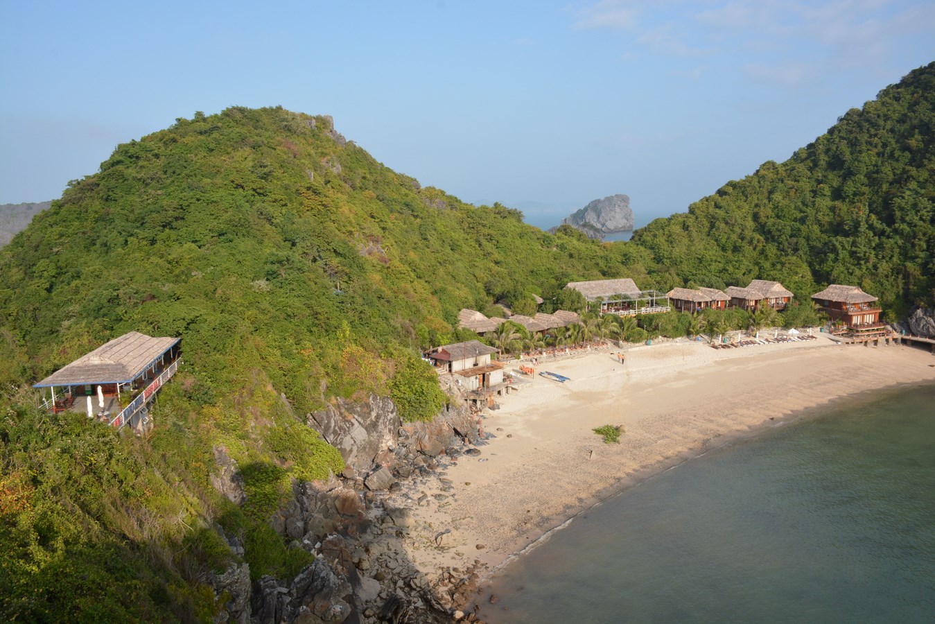
People go out to the island for the two crescent-shaped beaches Cát Dứa 1 and Cát Dứa 2, and for the trail up to the island's summit to see the whole of Lan Hạ bay.
Seba Della y Sole Bossio (Flickr: sebadella) · CC BY 2.0 · source
Getting there and around
You can only get to the island by boat or speedboat from Bến Bèo (Cát Bà town). Most sightseeing boats in Lan Hạ bay stop at the island, for example the Bến Bèo – fishing village – Đảo Khỉ route. The trip out to the island costs a boat fare. Services at the beach are simple: thatched huts selling drinks, float rental, and they may be open only seasonally.
Before you go
The monkeys are bold around people: they fight over food, snatch phones and cameras, and can scratch and bite. Do not feed the monkeys, keep food and phones tucked away, and keep your distance; if you are scratched or bitten, see a doctor immediately. The path up to the summit is steep, with sharp rock, no railings and slippery after rain, so you need shoes with grip. No official source confirms that the beach has lifeguards, so only go into the water when the sea is calm. The storm season in Hải Phòng is June–September; when there is a storm, sightseeing boats in the Cát Bà bays and sea bathing are stopped. Kayaking in the Cát Bà bays was ordered to stop from 15 Nov 2024, and no document allowing it to resume has been seen.
What this place is
Đảo Khỉ (Monkey Island) is a small forested limestone island in the middle of Lan Hạ bay. Its old name is Cát Dứa, because wild pineapples grew on the island, and a walk around the shore is less than 3 km. The troop of monkeys on the island was released by forest rangers in 1993, mostly long-tailed macaques. This is not a native population and not the Cát Bà langur. The island belongs to the Cát Bà archipelago: a world biosphere reserve since 2004, and part of the Hạ Long Bay – Cát Bà Archipelago World Natural Heritage site since 2023.
Busy and quiet times
May–August is summer in Lan Hạ bay: the sea is calm, the sky is clear, and it is also the busiest time.
Photographs
11 of 13 on filePaul Arps · CC BY 2.0 · source
Seba Della y Sole Bossio (Flickr: sebadella) · CC BY 2.0 · source
pululante (Flickr) · CC BY 2.0 · source
Viethavvh (vi.wikipedia) · Public domain (PD-user) · source
Chris Conway, Hilleary Osheroff (Flickr: chrisandhilleary) · CC BY-SA 2.0 · source
Vuong Tri Binh · CC BY-SA 4.0 · source
TomFitzhenry · CC BY-SA 4.0 · source
Paul Arps · CC BY 2.0 · source
Vuong Tri Binh · CC BY-SA 4.0 · source
puffi_thebikingnaturalist (iNaturalist) · CC0 1.0 · source
Paul Arps · CC BY 2.0 · source
The story
Monkey Island — the island that was once Cát Dứa
Picture a small, forest-covered rock island in Lan Hạ Bay, so small that a loop around its shore is under 3 km. People call it Đảo Khỉ — Monkey Island. Before that it was Cát Dứa, named for the wild pineapples (dứa) that grew thickly on the island. The old name never left. It still sits on the island's two crescent-shaped beaches: Cát Dứa 1 and Cát Dứa 2.
Vibe
Tags
Source
The island's identity was cross-checked between the Google Maps pin 'Đảo Khỉ' (looked up by hand by the product owner on 2 Oct 2026) and OpenStreetMap: the coordinates lie within the polygon of the island 'Monkey Island'. The former name Cát Dứa comes from VnExpress's Cát Bà guide (edited 16 Apr 2026) and the Cultural Heritage portal (dsvh.gov.vn). The shape, the two Cát Dứa beaches, the path to the top and the story of monkeys snatching food come from the Cát Hải information portal (original post 8 Oct 2013). The history of releasing the monkeys from 1993, the long-tailed macaque species and the risk of being bitten come from Dân trí (8 Aug 2005). How to get there by boat from Bến Bèo and the bay's summer season come from VnExpress (2023). The storm-season and monsoon markers come from the Maritime Search and Rescue Coordination Centre. The rules on halting boats and sea bathing during storms come from VnExpress (16 Jul 2023). The order to stop kayaking comes from Tuổi Trẻ (20 Nov 2024). The UNESCO milestones come from the Ministry of Culture, Sports and Tourism (16 Sep 2023). The warning about the trail and the fact that the beach has no lifeguards come from the private travel guide vietnamtourism.com (12 Jul 2026). What was rejected: the sentence 'the second largest island of the archipelago' (wrong against OpenStreetMap geometry, about 0.14 km²); every figure for the distance to the town (sources give from 1 to 12 km, self-measured about 3.2 km); the 2021 ticket price (outdated); the boat travel time; the tour seller's sentence 'very safe to swim'; the beach length; snorkelling over coral; kayaking as an activity currently offered. Not verified: the body that manages the island, whether the island lies in a heritage core zone or the national park, the state of the resort on the island, and the number of monkeys today. Photos come from Wikimedia Commons, Flickr and iNaturalist, each credited under its own licence.
Place data is compiled from many sources across the internet by a team of automated AI agents that collect, enrich, check, challenge, score, edit, review and verify it.
Ratings & comments
Anyone can read. Sign in to rate, comment and like.