Photo: Duyphuong (vi.wikipedia: Phuongcacanh) · CC BY 3.0
Tam Đảo, Phú Thọ · Nature
Tam Dao
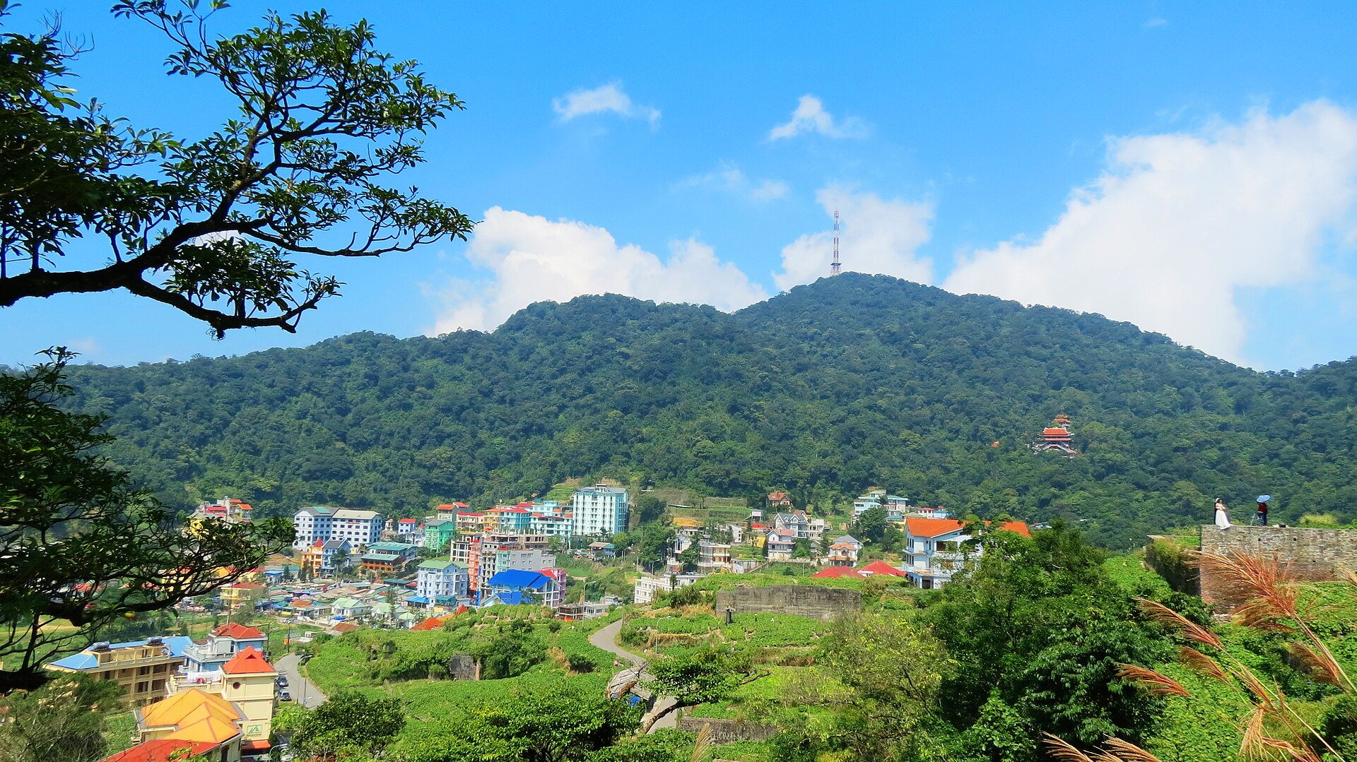
A small hill-station town on the back of the Tam Đảo range, lying inside the boundary of Tam Đảo National Park — not the whole mountain range, and not the whole national park. It is cooler than the lowlands all summer and the fog is almost constant; Thác Bạc (Silver Waterfall) is right in the town, and the park's evergreen forest begins just around it.
What people come for
Spring is the rhododendron (đỗ quyên) season, blooming along both sides of the road up to the resort, in every lane and across the hillsides; summer is the butterfly season around the trails and along the streams (Tam Đảo National Park website). In town are Thác Bạc and a stone church from the French era, the French-era building most clearly still standing in the centre after most of the old villas were lost in the war.
VŨ HÙNG · CC BY-SA 3.0 · source
Getting there and around
There is effectively only one way up to the town: the pass road of National Route 2B, winding with many hairpin bends in a row and limited visibility; on days of thick fog the road surface is slippery, and prolonged heavy rain has caused earth and rock to slide onto the road. The National Park runs guided walking routes, including one past the Vietnam Bear Rescue Centre and the Lũng Chắt Dậu valley; these routes charge an entry ticket at a low tier, with a separate rate for pupils and students, and hiring a guide is charged separately (Tam Đảo National Park website, page with no publication date).
Before you go
Unauthorised mountain climbing and trekking inside the National Park is strictly forbidden — legitimate forest walks are on routes run by the Park's Ecotourism Centre, with a guide; the management board names five hazards explicitly: getting lost, slipping, drowning, flash floods and accidents in the forest (Tam Đảo National Park website; Công Luận). As of 16 Sep 2026 both climbing routes around here are suspended until further notice — the three-peak route Thạch Bàn – Thiên Thị – Phù Nghĩa since 5 May 2026 and the Tam Đảo Bắc peak trekking route since 25 Apr 2026 — while the stone-step path down to Thác Bạc is steep and very slippery on rainy days.
Sketyl none · CC BY 2.0 · source
What this place is
A very small hill-resort town on the back of the Tam Đảo range, within the services and administration zone of Tam Đảo National Park, a special-use forest spread across three provinces: Phú Thọ, Thái Nguyên and Tuyên Quang. The air is clearly cooler than the plains throughout summer and truly cold in winter, and mist is a constant visual feature — the local newspaper calls it a 'cảnh sắc mờ sương đặc trưng' (a characteristic misty landscape).
Busy and quiet times
This is a familiar cool-air retreat for visitors from the north: numbers rise sharply from late spring and concentrate on weekends and summer holidays, so to avoid the crowds skip weekends and public holidays.
Eating
Chayote (su su) has been grown here for nearly a hundred years and suits the climate and soil so well that no other area in the province can match it; chayote vines covering hillsides and fences are part of the town's landscape, and chayote shoots are what visitors take home (Phú Thọ tourism portal).
Photographs
NKSTTSSHNVN · CC BY-SA 4.0 · source
Viethavvh (vi.wikipedia) · Public domain · source
NKSTTSSHNVN · CC BY-SA 4.0 · source
Nhcuong81 (vi.wikipedia) · CC BY 3.0 · source
Bùi Thụy Đào Nguyên · CC BY-SA 3.0 · source
Bùi Thụy Đào Nguyên · CC BY-SA 3.0 · source
Nhcuong81 (vi.wikipedia) · CC BY 3.0 · source
Letrungdungcz · CC BY-SA 4.0 · source
Letrungdungcz · CC BY-SA 4.0 · source
NKSTTSSHNVN · CC BY-SA 4.0 · source
Bùi Thụy Đào Nguyên · CC BY-SA 3.0 · source
Bùi Thụy Đào Nguyên · CC BY-SA 3.0 · source
Bùi Thụy Đào Nguyên · CC BY-SA 3.0 · source
Letrungdungcz · CC BY-SA 4.0 · source
The story
Tam Dao — an old hill station inside a national park
Picture a town small enough to walk end to end in a single morning, set on the back of a mountain range with forest on every side. This is not the whole Tam Dao range, and not the whole national park — only one hamlet tucked inside the forest: Tam Dao hamlet, Tam Dao commune, Phu Tho province. Directly overhead stand three mountain blocks named Thach Ban, Thien Thi and Phu Nghia, the three "mounds" that gave the place its name (tam dao means three isles). The range runs northwest to southeast across the territory of Phu Tho, Thai Nguyen and Tuyen Quang; the town itself sits inside the boundary of Tam Dao National Park, a special-use forest spread over those same three provinces, its core zone closed to all extraction and hunting. The place is known for its mist — though nobody can promise the mist will be there on the day you arrive.
Vibe
Tags
Source
Profile built from public sources, cross-checked on 16 Sep 2026. The entity's identity and location were matched against OpenStreetMap node 369491674 (place=town, wikidata Q10823894) via the Overpass API; the administrative unit follows an article on the Government's Policy-Building Portal (23 Jun 2025) about the establishment of the new Tam Đảo commune, so this profile no longer uses 'Tam Đảo district, Vĩnh Phúc'. Climate and the origin of the hill station: Thanh Niên (27 Oct 2024) and Thanh Niên (stone church). Rainy season, fog and the rhythm of crowds: Báo Phú Thọ (12 May 2026). Rhododendron season: Báo Dân tộc và Phát triển (8 Mar 2024). Butterfly season, the guided walking routes, the Vietnam Bear Rescue Centre and the ban on unauthorised mountain climbing: the Tam Đảo National Park page. Warnings about forest trekking: Công Luận; the pass road on National Highway 2B: Dân trí (12 Apr 2026); the stone steps at Thác Bạc: VnExpress (2022). Two temporary suspensions of mountain climbing: Tuổi Trẻ (7 May 2026) and Dân Việt. The national park boundary was adjusted by Decision 1159/QĐ-BNNMT dated 3 Apr 2026, as cited by the agriculture-and-environment press and Thái Nguyên radio-television. Su su shoots: Phú Thọ tourism portal. REJECTED and deliberately left off the page: the elevation of the town and of the three peaks (sources disagree completely), the figure of 134 butterfly species (actually the number of MOTH species), the area of 34,995 ha and all species counts quoted from a 2005 article, the ticket price of 20,000 VND (the source page is undated and the current rate differs), the number of steps and the height of Thác Bạc, the number of bears in 2013, the threat level and legal basis of the Tam Đảo salamander, public wifi (a 2013 scheme), the distance to Hà Nội (three figures for three different entities), and a landslide on National Highway 2B on 21 May 2026 that has since been repaired.
Place data is compiled from many sources across the internet by a team of automated AI agents that collect, enrich, check, challenge, score, edit, review and verify it.
Ratings & comments
Anyone can read. Sign in to rate, comment and like.